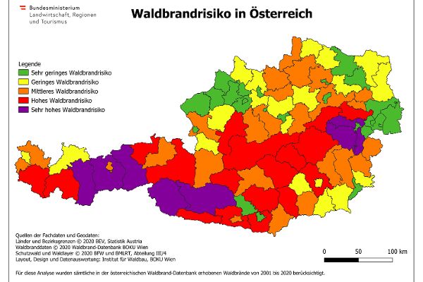
Forest fire risk map

The areal presentation in the form of a forest fire risk map illustrates the risk to forest stands, infrastructure and residential areas as well as potential impacts.
This map is based on the criteria of the European Forest Fire Information System (EFFIS) and the Joint Research Centre (JRC) and makes a key contribution to the identification of problem areas and challenges related to the development and combating of forest fires.
Methodology
The basis for the establishment of the forest fire risk map on district level is provided by the data of the Austrian forest fire database. All forest fire events surveyed in the period from 2001 to 2020 were used. In addition to the exact coordinates of each and every forest fire, also the areas of the relevant forest fires were taken into account - but only those having a total size of less than three hectares.
The Austrian Federal Research and Training Centre for Forests (BFW) and the Federal Ministry of Agriculture, Forestry, Regions and Water Management, Directorate III/4, processed geodata on the spatial distribution of forests that had been provided. The data sets allowed a classification of forests with a primary economic and protective function. As regards the protective function, a distinction was made between object-protecting forests and site-protecting forests.
This means that information on the number of forest fires, the total area affected by fire, the forest area with an object-protecting function, the forest area with a site-protecting function and the forest area without primary protective function was available for each district or each statutory city in Austria (Vienna was considered as a unit in this evaluation).
To prepare the forest fire risk map seven basic maps were used and combined via a weighting function. On the one hand the start of forest fires was to be considered by means of data on the number of forest fires, on the other hand the behaviour of forest fires was to be taken into account by means of data on the size of the fires. Greater emphasis was placed on forests having an object-protecting or site-protecting function.
Result
Taking everything into account 50 out of 94 districts and statutory cities in Austria were classified at least as risk level 3 (medium forest fire risk).
The forest fire risk map prepared on district level allows a quick first assessment of the national risk of forest fire to support the requirements in respect of the planned implementation of the Forest Fund Act (“Waldfondsgesetz”).