Hazard zoning
Hazard zoning is the visualisation and assessment of natural hazards in accordance with the applicable legal situation, in particular the Forestry Act 1975 as amended.
Strategic positioning
The Torrent and Avalanche Control Service provides updated state-of-the-art Hazard Zone Plans as required by the Forestry Act. On the basis of these Hazard Zone Plans, the dangers and risks are updated in accordance with the provisions of Community law.
The Hazard Zone Plan (HZP) also allows a visualisation of the dangers for natural hazards from rockfall and landslides and thus also serves as a basis for action planning.
The Hazard Zone Plan of the Service for Torrent and Avalanche Control
A service for all municipalities
The Hazard Zone Plan of die.wildbach is prepared for all Austrian municipalities "harbouring" torrent, avalanche or erosion areas.
The Hazard Zone Plan is an area-based expert opinion on the dangers and is to provide the basis for spatial planning as well as for the construction and emergency management sectors.
The floods of 2002 in particular showed how important it is to take endangered areas into account in spatial planning. In order to identify the nature and extent of these dangers, Hazard Zone Plans as required by the Forestry Act 1975 (as amended), section 11, have for almost 30 years been prepared and made available to the municipalities as the competent bodies for local zoning and construction planning.
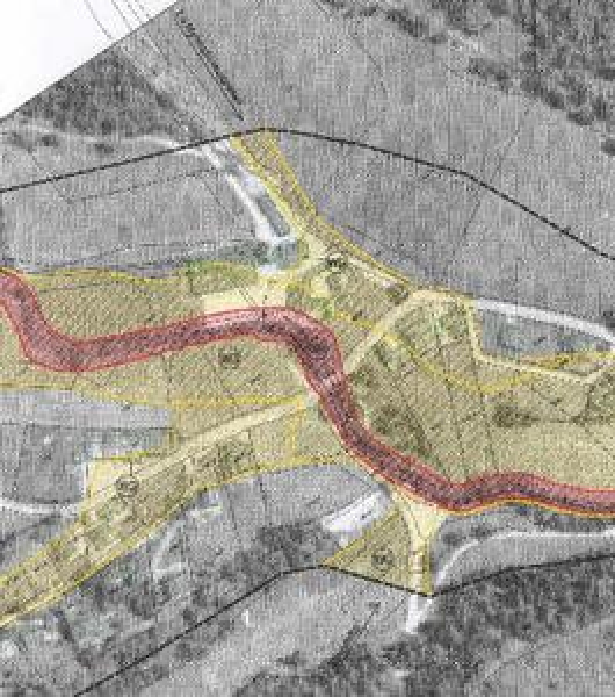
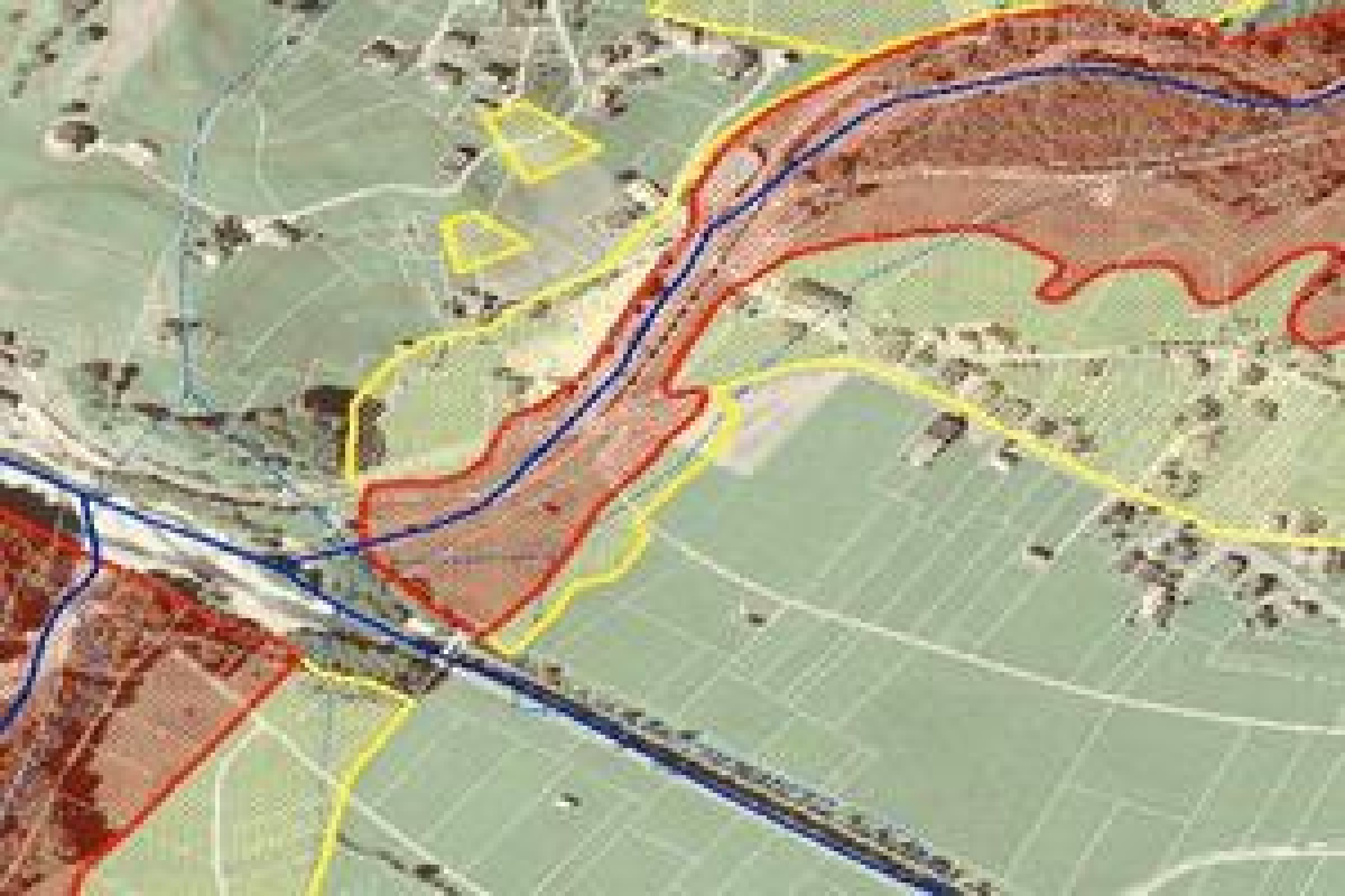
Contents of the Hazard Zone Plan
Within the "spatially relevant area" (black dotted line in the photo), the hazards due to torrents and avalanches are identified after intensive surveys in the catchment areas and evaluation of previous events. Based on the long-standing experience of the employees, the hazard level is visualised by differentiating between red and yellow hazard zones for each parcel of land.
Prohibition of building in Red Zones
According to the Ordinance of the Federal Minister of Agriculture and Forestry of 30 July 1976 on the Hazard Zone Plans, Federal Law Gazette No 436/1976, the Red Hazard Zone comprises those areas that are endangered by torrents or avalanches to such an extent that, due to the expected damage effect of the assessment event or the frequency of the hazard, their permanent use for settlement and transport purposes is not possible or is only possible at disproportionately high cost.
This means an absolute building ban for new buildings in Red Hazard Zones. Exceptions are only possible in cases where existing buildings are modernised and this modernisation leads to an increase in safety. This requires an "application for exemption from the consequences of an impediment", which can be submitted to Directorate III/4 of the Federal Ministry via the responsible Regional Headquarters (“Gebietsbauleitungen”).
Building subject to conditions in Yellow Zones
According to the Ordinance of the Federal Minister of Agriculture and Forestry of 30 July 1976 on the Hazard Zone Plans, Federal Law Gazette No 436/1976, the Yellow Hazard Zone includes all other areas endangered by torrents or avalanches whose permanent use for settlement or transport purposes is impaired due to this hazard.
Building in Yellow Hazard Zones is therefore possible subject to compliance with conditions that are stipulated in an individual report by the responsible area construction management during the construction process.
Reference areas and reserved zones
In addition, the Hazard Zone Plans also designate blue reserved zones (to be kept free for protection measures) as well as brown (other eugenic hazards, e.g. rockfall or landslides) and violet (e.g. necessary flooding zones) reference areas.
Duration of validity or revision of the Hazard Zone Plan
"If changes occur in the bases or in their evaluation, the authorities must adapt the Hazard Zone Plan to these changed circumstances." (Excerpt from the Ordinance of the Federal Minister of Agriculture and Forestry of 30 July 1976 on the Hazard Zone Plans, Federal Law Gazette No 436/1976.)
This means that the Hazard Zone Plan has to be adapted (revised) if the conditions in the catchment areas (e.g. due to technical control structures) or their evaluation (e.g. change in the criteria for assessing the hazard mechanisms) change.